A Snail’s Tale of Ancient Sherwood Forest
- Posted in:
- Archaeology
- Miner2Major
Miner2Major is a Landscape Partnership scheme supported by the National Lottery Heritage Fund. It encourages local communities to get involved in projects that celebrate the diverse wildlife, important habitats and rich heritage of Sherwood Forest.
Miner2Major focuses on the heart of the Sherwood Forest area from Nottingham to Ollerton, and Mansfield to Rufford Abbey, an area that has a distinctive landscape character, which is recognised and valued by local people, as well as visitors from around the world.
Sherwood Forest is famous for being the home of Robin Hood and his merry band, living deep in the impenetrable medieval forest. But was Sherwood Forest always like this? Snails found by archaeologists excavating a 2,000-year-old Roman well, tell a very different story.
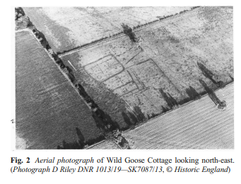
In the 1970s, crop marks were identified in an aerial photo in the area now known as Wild Goose Cottage, at Lound. The crop marks revealed evidence of two Iron Age Huts and three Romano British sub-rectangular enclosures.


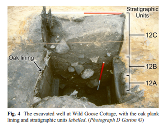
When the site was being cleared for mining in 1992, a well was discovered. The one-metre square well, lined with oak planks, was filled with household waste and soil (a common practice once wells are abandoned). Archaeologists collected soil samples from the well for paleoenvironmental analysis. The samples contained flora and fauna that lived in the well while it was operational, and soils from the surrounding area that were used to backfill it.
By sieving through these samples and extracting organic matter under the microscope, 163 species of seeds, pollen, and insects were identified. What did this evidence reveal? Firstly, the snail species present are known to prefer open habitats to dense forests. Secondly, pollens from cereals indicate open damp grasslands in the floodplain, while other species indicated drier, sandier pastures with hedged fields to the west. Finally, seeds associated with grazing animals and dung living insects suggest the keeping of livestock. This evidence enabled archaeologists to build a profile of an open, grazed landscape during the Roman times, more like today than the dense medieval forest.
The post-Roman development of Sherwood Forest is well documented. It was created as a royal hunting forest after the Norman Invasion of 1066. By the 1200’s it covered 100,000 acres. Medieval forests were carefully managed for their wood resources, but by the time of the Civil War, the forest was lacking proper management and in decline. Large areas were gifted to local aristocrats, forming the ‘Dukeries’. They profited from the sale of timber to the navy and for construction purposes. Deforestation continued with the Industrial Revolution and the two world wars. By the 1950s, the area was no longer economically viable. Forestry operations were abandoned, and wild woods began to flourish again. In 1954 Birklands was designated a site of Special Scientific Interest, leading to the creation of Sherwood Forest Country Park, a heritage site of international significance, popular for recreation and tourism.
Human activity has transformed Sherwood Forest over the centuries. Using paleoenvironmental data, archaeology, and historical records, we can develop an understanding of the evolving relationship between people and Sherwood Forest, through time.
Find out more using the links below:
The history of Sherwood Forest
Recommended additional reading:
'Caught in a trap: landscape and climate implications of the insect fauna from a Roman well in Sherwood Forest'. Archaeological and Anthropological Sciences 10:125–140. Paul C. Buckland & Philip I. Buckland & Eva Panagiotakopulu. 2018.

