The iconic K6 telephone kiosk, more commonly known as the red telephone box, dates to 1935. It was designed by the famous British Architect, Sir Giles Gilbert Scott, to commemorate the Silver Jubilee of the coronation of King George V.

The K6 was the first telephone kiosk to be employed extensively outside of London. It was made from four cast-iron sections, bolted together and installed on a concrete base. Three of the sides, which included the teak door frame, were glazed with eight rows of three panes of glass windows, in a decorative mould surround. The ‘telephone’ sign at the top was illuminated. The domed roof incorporated a moulded royal crown representing the current monarch at the time of installation. Three crowns can be found on K6 kiosks: King George V, King George VI and Queen Elizabeth II. The standardised paint colour is ‘currant red’.

Photograph of an iconic K6 Kiosk at Maythorne Mill

Above: An iconic K6 Kiosk at Maythorne Mill. Check out the HER record here.

By 1968, 60,000 original K6 kiosks had been installed by the General Post Office, making them a familiar sight throughout Britain. Ordinary homes did not have a landline until the 1950/60s, so public telephone boxes were vital for communications. They were sited in the main areas where people would pass by, often close to road junctions. In high footfall areas such as the marketplaces at Newark and Bingham, pairs of kiosks were installed.

Photograph of two pairs of K6 kiosks at the Market Place, Newark

Above: Two pairs of K6 kiosks at the Market Place, Newark. Google Image. Check out the HER record here.

In the 1980/90s K6 kiosks began to disappear as they were replaced with a more modern design. The introduction of mobile phones in the 1990s, made telephone boxes virtually redundant, and many more disappeared from the street scene. In 2017/18, British Telecom wrote to councils offering them the option to purchase redundant K6 kiosks in their area for just £1.  Many were purchased and repurposed by councils and community groups for a range of uses. In Nottinghamshire, K6 boxes are commonly used to house defibrillators and book exchanges. One in Ravenshead has become a floral display, while others have been incorporated into museums and public places (Newark Air Museum). Some can even be spotted in domestic properties where they are sited as garden features.

Photograph of a K6 Kiosk defibrillator adjacent to Martins Arms Public House, Colston

Above: K6 Kiosk now houses a defibrillator adjacent to Martins Arms Public House, in Colston. Check the HER record here.

In 2022, it was estimated that 11,700 K6 kiosks remained. As one of the most recognisable symbols of 20th-century British design, Historic England considers the best-surviving K6s to be an important part of our national heritage. So far, almost 2,500 have been Grade II listed. 38 of these are in Nottinghamshire. You can find out which ones, by entering 'K6' in the search bar of our website here.

These listed examples serve as reminders of the era when phone boxes were an essential part of communities across Britain. The iconic design of these modest yet striking structures has secured their place in our national heritage.

Miner2Major focuses on the heart of the Sherwood Forest area from Nottingham to Ollerton, and Mansfield to Rufford Abbey, an area that has a distinctive landscape character. Just like archaeological sites, historical sites, monuments and historic buildings, the landscape is an integral part of the historic environment. Place names establish identity and assist communications, but historic maps show us that place names change through time. How do these changes help us unravel history?

Place names can tell us stories that would otherwise be unknown. Often made up of two elements, a prefix and a suffix, the names can be decoded to reveal natural features that may have disappeared, ownership or the character and origins of a settlement. Through the centuries, place names have evolved, reflecting historical, linguistic, and cultural changes. The evolution of place names is called Etymology.

Anglo-Saxon Names

Many names are rooted in Old English, the Germanic language that was brought to England by the Anglo-Saxons, and in-use between the mid-5th to 12th centuries. Anglo-Saxon place names take different forms. Some refer to people or animals in the prefix, followed by a suffix that denotes ownership. Examples include Blidworth, probably meaning Blida’s Farm, and Ravenshead, high ground named after the bird or a man bearing that name. Others refer to the landscape, ending in ‘field’ (Mansfield) or ‘ley’ (a clearing), (Annesley).

Settlements and towns were given names ending in ‘ham’, ‘tun’ or ‘ton’ (Ollerton). A fortified town is indicated by the suffix ‘burh’ ‘brough’ ‘borough’, ‘burgh’ or ‘bury’, for example the hamlet of Brough, built around a Roman military settlement.  

Places with a religious connection often end in ‘minster’ or ‘stow’. Edwinstowe is documented in the Domesday Book of 1086 as ‘Edenestou’. The name commemorates the legend of the body of King Edwin of Northumbria, being laid to rest near here after he was killed in battle in 632. Many other spellings occur over the centuries Hedenestoua (1173), Edenestowa (1194), Eddenstowe (1287); Edwynstow (1300); Edenstow (1577); Eddingstowe (1633).

Modern Edwinstowe overlying Chapman’s map of 1774.

Above: Modern Edwinstowe overlying Chapman’s map of 1774.

Viking Names

The Viking settlers of the 9th and 10th centuries left their mark on the Nottinghamshire landscape, with place names ending in ‘by’, the Danish word for town, or ‘thorp’ meaning settlement of Danish people. Examples of these include Walesby, Budby, Bilsthorpe and Perlethorpe. The prefix of the name can also reveal clues about the landscape. Linby for example, means Lime Town and’ Kirk’ indicates a church (Kirkby and Kirklington).

The Domesday Book

The first large-scale survey of England was commissioned by William the Conqueror in 1086. The Domesday Book was a comprehensive survey of the land and resources in England to be used as a tool for taxation and governance. This was probably the first time place names in Nottinghamshire were officially written down. The Norman surveyors were French speakers and whenever they encountered a tricky name, they simplified it and recorded a variation that was easier for French speakers. Sometimes they added ‘bel’ or ‘beau’ as a prefix (Beauvale).

Maps

One of the oldest maps of the area was drawn by Joan Blaeu in 1646. Most of the names are recognisable, but the spelling of place names in maps and documents continued to vary due to mispronunciation and inconsistent spelling. Several variations of a name might be in use at the same time. It was not until the first Ordnance Surveys in the 1840s that the spelling of place names became standardised.

Joan Blaeu Map 1646

Above: Joan Blaeu Map, 1646. Reproduced with the permission of the National Library of Scotland CC_BY (NLS). Visit the Blaeu Atlas here: Map

Place names are still not set in stone. Some place names are relatively new where new settlement or industry occurs, and some do change. Clipstone and King’s Clipstone are good examples. King’s Clipstone is recorded in the Domesday Book (1086) as ‘Clipestune’. King Edward I, bestowed the prefix King ‘Kyngesclipston in 1290, after parliament was held at King John’s Palace. As its importance declined, it became simply known as Clipstone, then Old Clipstone as the new Clipstone Colliery village grew in the 1920s. In 2011, the community chose to reinstate the medieval name of Kings Clipstone to create a distinct identity separate from the colliery village of Clipstone.

Kings Clipstone shown as ‘Clipstone’ on Sanderson’s map of 1835.

Above: Kings Clipstone shown as ‘Clipstone’ on Sanderson’s map of 1835.

Place Name Etymology in the Miner to Major Landscape Partnership Area.

Below are other examples of place name etymology in the Miner to Major project area, recording the name changes as shown on dated maps or documents.

Wellow - First attested in 1207 in pipe rolls as Welhag’. Also, Welagh (1316), Wellehach’ (1250); Wellhawe (1275); Whellay (1494); and finally, Wellow in 1747. The word is a compound word from Old English: wielle and haga, referring to an enclosure of some kind near to a spring. A small tributary of the Maun is nearby and could refer to that.

Blidworth - First attested in the Domesday book in 1086 as Bliedeworde. Also, Blieswurda (1158); Blithewurth (1240); Blittewrth (1271); Blideth (1670). Blieworth probably means “Blida’s Farm”.

Annesley - First attested in the Domesday book in 1086 as Aneslei. Also, Anisleia (1190); Anyslegh (1250); Ansley (1590). Possibly a compound of a personal name An with Leah (meaning An’s clearing).

Linby - First attested in 1086 in Domesday book as Lidebi. Also, Lindebeia (1316); Linneby (1233); Lundeby (1304); Lynby (1392). From Old Norse linda býr, meaning “lime-tree village”.

Bestwood -First attested in 1177 as Beskewuda in the pipe rolls. Also, Beescwde (1200); Buskwud (1207); Bekeswood (1523); and finally, Bestwood in 1619. From Old English bēosuc, a derivative of the Old English word bēos(e), meaning bent grass (how Beeston also gets its name). Therefore, Bestwood means “wood where bent grass grows” in Old English.

Ollerton - First attested in the Domesday Book in 1086 as Alretun. Also, Allerton (1276); Alverton (13th c.); and Ollerton by 1316. From the words alor and tun, meaning “farm of the alders”.

Papplewick - First attested in the Domesday book in 1086 as Paplleuuic. Also, Papelwich (1316); Papewich’ (1165); and Papleweeke. Formed from the words pappol(stan) and wic, meaning “dairy farm in the pebbly place” in Old English. As noted by some researchers, some fields on the east side of the village are very pebbly.

Ravenshead - First attested in 1205 as Ravenesheved. Literally means “Raven’s Head” It is the highest ground in the neighbourhood and the hill may have been so called from the bird or from a man bearing that name.

Newstead - “New Place”. The place obtained its name at the time of the foundation of the Austin Priory here by Henry II.

Warsop - Domesday book 1086 as Wareshope. Also, Wyrssop (1321-4); Worsoop (1569); Warsopp Church towne, Warsopp Markett towne (1653). The second element of the word is hop, “valley”, the well-marked valley between the two settlements at Church and Market Warsop being the determining factor in the original settlement. Warsop means “the Valley of Wǣr” (Wǣr being an Old English personal name).

Miner2Major Logo Banner

Follow the project: Instagram | Twitter | Facebook

‘This road was built by the Romans, see how straight it is!’

A phrase said by many-a-parent to their kids on long road trips as an attempt delay the inevitable ‘are we nearly there yet’ question. If you are anything like me, you’d peer out of the car window in wonder, watching the hedgerows and signposts swoosh past, trying to imagine instead a scene filled with Roman soldiers in bright lorica segmentata armour and banners fluttering in the breeze.

Some of these great highways built by the Romans became so embedded in our later infrastructure that they are major highways nearly 2000 years later. The A46 Fosse Way, which runs askew through Nottinghamshire from Gallows Nooking in the east to Broughton Lodge in the south, is one such road. Laid and re-laid, tweaked, and re-routed over the centuries to the point where in places the modern route has been altered entirely to avoid and protect Roman towns, like Margidunum.

When you see a long straight road on a map you may wonder ‘was that built by the Romans?', but how do we find out if that was the case? For some roads it is pretty straightforward. Many of our well-known Roman roads, like the Fosse Way and the road from Lindum (Lincoln) to Danum (Doncaster), are detailed in the Roman versions of road maps called ‘itineraries’. These aren’t maps in the same way we imagine them, but rather lists of places you will find along certain roads and the distance between them. This is how we can know the names of some of the deserted towns like Segelocum (Littleborough) and Crococalana (Brough).

Map of the Roman road stretching from Kirklington to Bilsthorpe

Above: Map of the Roman road stretching from Bilsthorpe to Kirklington.

But the Romans built more roads than we have itineraries for, so how can we spot the rest?

The problem with identifying Roman roads is that they were built a long time ago and nearly 2000 years has since intervened. Some routes went out of use as soon as the army didn’t need them in the early years after invasion, others when the Roman infrastructure broke down as Rome abandoned the province. Others remained in-use as long-distance highways that didn’t necessarily link places where people lived but were useful for getting around. The A46 in Nottinghamshire is a good example of this. In some cases a Roman town persisted, such as Lincoln, and the Roman roads became embedded in the later settlement structure.

People try to spot Roman roads by looking for straight ones, but they aren’t all ruler-straight, especially after 2000 years. The Romans were efficient with their road building, but not stupid, and would squiggle to avoid some things and to course-correct. If the road survived, with only sporadic local maintenance, it might wander across the landscape as it ebbed and flowed with use, much like the meandering of a river.

There are plenty of red-herrings too! Enclosure of common land, following the 1750 enclosure acts, led to the creation of new roads which were also straight and broad and often with many boundaries and roads at right-angles to them. So, there are subtle clues you have to look for to decide whether you’re likely looking at a Roman road or an enclosure one.

Without digging and finding the Roman road surface, we have to go on the ‘balance of evidence’. Does it link places of significance in Roman times? Does it appear to pre-date the other boundaries in the area? Even where we know that we are looking at a Roman road such as the A46, it was very rare that the recent dualling work uncovered anything that looked like the original road surface.

The reality is that some routes that we use today may be very old indeed, while others exist only as the ghosts of trackways appearing as cropmarks in fields. For most of them their origins will remain elusive until we have more evidence that we can piece together.

Miner2Major is a Landscape Partnership scheme supported by the National Lottery Heritage Fund. It encourages local communities to get involved in projects that celebrate the diverse wildlife, important habitats, and rich heritage of Sherwood Forest. A significant aspect of the heritage is the role this area played during World War I. 

WW1 Clipstone Camp Monument record MNT27602

Miners working on the Nottingham coalfield were quick to volunteer to join Lord Kitchener's New Army in August 1914. In fact, within the first month, 300 local men, mostly miners, had enlisted at Mansfield into the Sherwood Foresters Battalion, which forced the newly opened Clipstone Colliery to close (Marples, 2013, pp. 11-12).

Across the country, more than 2.5 million men answered the call. The Duke of Portland offered his land for military use and a new training camp was built. Clipstone Camp became the largest training facility in the country, housing between 20,000 and 30,000 soldiers at a time between 1915 and 1921. Soldiers from all over the country trained at Clipstone.

Map of Clipstone Camp

Above: The site of Clipstone Camp. The green areas mark the northern and southern lines of the WW1 Camp.

The camp was built on the open heathland in the area between Clipstone Drive and Mansfield Road. The wooden huts were organised in lines to accommodate whole battalions. Training exercises took place in the surrounding countryside, which includes areas now known as Sherwood Pines Forest Park, Vicar Water Country Park, and Strawberry Hill Wood. Some remnants of trenches and rifle ranges can still be seen in these areas today. As the camp grew, more facilities were added, including a hospital, a railway, churches, and a theatre. The hospital received wounded soldiers evacuated from the battlefields. Of those who sadly died there, 28 soldiers and one nurse are buried in St Alban’s churchyard in Forest Town.

WW1 Clipstone Camp plan over current mapping

Above: The WW1 Clipstone Camp plan (War Office, 1915) over current mapping (insightmapping 2023, Nottingham City Council).

The local communities of Forest Town and Mansfield welcomed the soldiers and offered their hospitality. In return, the camp held public open days, giving visitors a glimpse into the lives of their loved ones serving overseas. A highlight was the tour of the hut gardens, which were carefully created and maintained by the soldiers. The soldiers also enjoyed tours of the mine, swimming in Vicars Water and joint sporting and musical events. Local women were keen to do their bit by volunteering in the camp as nurses, maids, and caterers.

After the war, the camp became a demobilisation centre, with the last men leaving in 1921. The huts and equipment were sold at public auctions and many huts were purchased for housing and community use. Some were kept for use by the colliery village when it reopened in 1920. The Church hut remained in use by community groups until the 1950s.

The huts and parade grounds of the former camp were overlaid by new colliery housing in the 1920s. Many of the roads still follow the original lines of the camp. Today, apart from memorials at the Social Club and Vicars Water, there are few reminders of the impact of World War I on this small Nottinghamshire community.

Suggested reading:

Miner2Major Logo Baner

www.miner2major.org.uk

Follow the project: Instagram | Twitter | Facebook

Strawberry Hill is a Nottinghamshire Wildlife Trust (NWT) nature reserve, and up until recently, records within the nature reserve and surrounding area were scarce, with no recorded archaeological work having been carried out on site before. The scarcity of records is likely a result of the extensive mineral extraction activities which were carried out before archaeological considerations were drawn into the planning process. There is a wealth of documentary evidence that indicates Strawberry Hill was once a significant landscape feature and way-marker.

Strawberry Hill has been a significant feature in the landscape since Medieval times and it appears, under different names, on numerous historic maps as well as Medieval perambulation documents. It sits on the historic boundary between the land of the abbots of Rufford and the land of the King’s manor of Mansfield. 

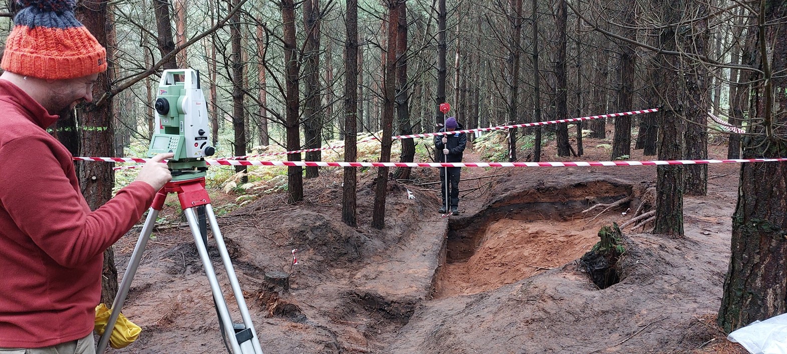
Recently, as part of the Miner 2 Major Veiled Landscape project, the area was subject to an archaeological survey, where NWT volunteers and a Nottinghamshire County Council archaeologist used lidar data to help guide the on-the-ground recording of previously unrecorded archaeological features. This survey enhanced our knowledge of the presence and significance of archaeological features and resources within the woodland.

LiDAR image showing earthworks within Strawberry Hill Nature Reserve

Above: LiDAR model showing earthworks within Strawberry Hill Nature reserve.

Several hollow ways survive within the woodland, one set of which is a well-used Medieval routeway that went out of use some time in the post-Medieval period. These are sections of deeply eroded ‘U’ shaped hollow ways that almost certainly represent a Medieval routeway between Mansfield and Bilsthorpe, which passes by Inkersall on the north side of the dam. This appears on the 1637 map of the Rufford Estate drawn by Bunting. Given the significance of the hill here in the landscape, historically it is possible that some of the other recorded hollow-ways may have significant age to them.

NWT volunteers and Nottinghamshire County Council archaeologist Emily Gillott standing in the contours of the Medieval hollow way

Above: Nottinghamshire Wildlife Trust volunteers and Nottinghamshire County Council archaeologist Emily Gillott standing in the contours of the Medieval hollow way.

There is also a well-preserved set of practice trenches from army training activities from the earlier 20th century This is part of a wider landscape that is characteristic of this part of Nottinghamshire, as many of the large estates turned over some of their land to military usage.  Many classic features of the trench warfare system are apparent including the classic zig-zag plan and communication lines dug to connect parallel trench sets. 

You can explore these records and the lidar survey data by searching in the database for the records below:

You can learn more information about the Veiled Landscape Project and the application of lidar here: The Veiled Landscape: Sherwood Lidar Project - Nottinghamshire Historic Environment Record